History of Bradbury
The following text is from "Campbelltown's Streets and Suburbs - How and why they got their names" written by Jeff McGill, Verlie Fowler and Keith Richardson, 1995, published by Campbelltown and Airds Historical Society. Reproduced with kind permission of the authors.
The suburb of Bradbury is named after one of Campbelltown's most prominent pioneers - and one of its most colourful drunks.
William Bradbury owned a sweeping farm south of the town, and was notorious for his drinking bouts. Local historian, Dr Carol Liston, has suggested the innkeeper was drunk more often than not. She wrote: "The magistrates refused to prosecute when Bradbury's watch was stolen because it was a regular town sport to bet on how long it would take Bradbury to sober up and discover his watch was missing."
But in the rum-soaked colony that was NSW, Bradbury's exploits did little to harm his considerable reputation.
During his last visit to the area in 1822, Governor Lachlan Macquarie wrote: "Mr Bradbury is now building a very good two-storey brick house on his own farm, and on a very pretty eminence immediately adjoining Campbell-Town...". Asked to give a name to the property, Macquarie portrayed a delightful lack of imagination by calling it Bradbury Park (house).
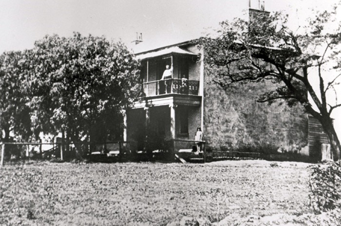
Bradbury Park House in 1918. Photo Claude Haydon Collection
When the old innkeeper died at the age of 67 in 1836, his large estate of 300 acres passed on to other owners until a section of it was subdivided into small farm blocks and town allotments in October 1844.
But until the 1950's, the hills of the modern suburb remained cow paddocks. Half a dozen farms were scattered across the slopes, one of the more prominent being that owned by Jeremiah Quirk. (A park situated on a portion of his old property has been called Quirk Reserve.)
Another prominent property was Raith, built by the Merewhether family in 1903. This was later owned by the Plaskitt family who erected an adjoining home called Lark Hill. These were purchased by the Child Welfare Department in 1964 as homes for young wards of the State.
But the major land holding remained Bradbury Park House, and from the 1890's until his death in 1928, the owner of the old house was Alderman James Quilty. On passing, the local newspaper described the estate as "one of the finest properties in the Campbelltown district".
The first suburban development came with the famous St Elmo Estates of the mid-1950's. But at the time, Bradbury suburb did not exist, so the new streets were all part of Campbelltown. A modern boundary has since been set along Bradbury Avenue (named after the innkeeper himself) and Hoddle Avenue, which recalls Robert Hoddle, the surveyor who first mapped Campbelltown in 1827.
Of the six St Elmo streets which now sit on the Bradbury side of the border, two payed tribute to men involved in the estate's creation. Lewis Street honoured the surveyor, Wal Lewis, while architect, James Donaldson, remembered by Donaldson Street.
Other thoroughfares recalled grantees who originally held land included in Bradbury Park - (Joseph), Phelps Crescent and (James) Bland Street. It's thought Chisholm Street was named after James Chisholm (1806-88), owner of Gledswood, near Camden. James Bocking, the mayor of Campbelltown from 1890-91, is remembered by Bocking Avenue.
But as the first homes began to appear, a major link with the past was lost forever. In 1956, William Bradbury's 134-year-old home was demolished. Asher Place now stands in its place - ironically on the Campbelltown side of the boundary.
The green hills south of Hoddle Avenue were earmarked to become another St Elmo estate, but in 1959 they were sold to the Lend Lease Corporation and renamed Macquarie Heights and Macquarie Views Estate. The first homes were approved by Council in August 1960, and as a street name theme, Lend Lease chose prominent figures from Australia's colonial past.
The early naturalists were honoured by (George) Caley Street and (William) Lewin Crescent. Gipps Street noted Sir George Gipps, Governor of NSW from 1838-45, while Macleay Street was a tribute to early colonial secretary, Alexander Macleay, who owned Brownlow Hill near Camden. Two famous emancipists were also immortalised with (Henry) Kable Road and (Mary) Reiby Place.
Local parish maps were studied, revealing land grantees such as (Ruben) Uther Avenue, (William) Guise Road, (George) Taber Place, and (Joshus) Alliot Street.
Campbellfield Avenue was named to preserve the title of William Redfern's property at Minto, while Bow Bowing Crescent recalls the creek.
The road skirting Macquarie Heights Estate was named St John's Road after the St Johns Preparatory Boarding College, which stood nearby and in 1970 became St Patrick's College.
Buoyed by its successes, Lend Lease planned a huge subdivision nearby. The CI News of January 28, 1964, gave the first reports of the 270-acre development in the "South Campbelltown".
The frontier nature of this new estate was highlighted in the hot February of 1965, when a grass fire swept through the first homes under contruction, and even threatened homes in Chisholm Crescent.
March 1965, saw the opening of the new estate, with Mayor Clive Tregear planting the first tree. Called Sherwood Hills, it became the most famous of all Campbelltown's estates and brought a "new style of living" to the area. Sherwood Hills was promoted as a "modern residential development" surrounded by parkland. Also featured was underground electricity, elimination of front and paling fences, and a ban on any red tiled roofs. Gardening was encouraged by Lend Lease.
With this in mind, the earlier streets were named for "green" images, such as Lawn Avenue, Fern Avenue, Poplar Crescent, Evergreen Avenue and Pine Avenue. The Estate's major arterial road, running along side Fishers Ghost Creek, was named simply The Parkway.
Until October 1965, the large stretch of parkland between Bradbury Avenue and the new estate had been known as the Fishers Ghost Creek Reserve. But in that month Alderman Arch Walker proposed it be renamed Bradbury Park, in honour of the early landholder.
This title was approved but Council, but it, soon sparked "disappointment" among some residents who feared the name of the town's ghoul would be lost. So Alderman Walker backed moves to call the creek reserve running across the new estate area Fisher's Ghost Reserve.
Some of Sherwood Hills' earliest home buyers were stunned to find cows eating turf they had laid in their front yards. But the march of suburbia was soon supreme and within three years, more than 350 homes had been finished.
In November 1967, Stage 2 was opened by Local Government Minister P.H. Morton, who planted an acorn from Sherwood Forest in England.
Street names continued under the "green" theme, some of these being Jacaranda Avenue, Blackbutt Avenue, Bottlebrush Avenue, Jarrah Crescent, and Coachwood Crescent.
In March 1967, after years of hope and months of construction delays due to wet weather, Campbelltown Swimming Centre was opened in "Bradbury Park". It was the climax of a campaign which stretched back years.
A "vital young suburb where young marrieds meet!" This is how Lend Lease was promoting Sherwood Hills in 1968. But this constant use of the estate name for a proper suburb title, led the Council to decide on a formal appellation. But what?
William Bradbury was at the time attracting a lot of attention. In July 1968, the P&C of the new school pointed out the facility was still unnamed and stated: "In nearly all cases everyone hopes (the school title) will be Bradbury." They got their wish and two months later, Council suggested the name for the entire suburb.
A barrage of complaints followed. Residents had used the Sherwood Hills title for years now, and thought it was far more euphonious than Bradbury. But Council argued the area planned to be included in the suburb covered a much larger area than just Sherwood Hills . It argued that householder of the Macquarie Heights estate may not welcome that name. Council also wanted an address with historical significance. In March 1969, the Geographical Names Board made it official.
Despite the new suburb name, Lend Lease continued to promote its estate by the popular old name. Stage three, south of St Johns Road, was advertised in 1972 as "Sherwood Hills...the garden estate that has everything".
But the handy stockpile of leafy street names was running low, so a new theme was chosen - Aboriginal words.
The first street named was Dewrang Avenue, the Koori description for "a high or lofty place". Quite apt, as this was the highest point of the new estate area. The first homes were exhibited as the "executive type" which would typify the subdivision.
Another 35 Streets would eventually be named under the Aboriginal theme. Meanings varied from Bimbadeen (good view), Weemalah (big frost), and Adina (good) to Dandar (pretty), Anembo (quiet place) and Tandara (camp here).
In the meantime, controversy had broken out over 27 villa units proposed by Lend Lease for a site between The Parkway and Greenoaks Avenue. Residents raised a hostile petition of 480 signatures and said they had not been told this type of development was planned. But Lend Lease claimed the "the town house trend" was not envisaged when the estate was started in 1965. After months of debate, Lockesley Mews, was opened in November 1971. Its name can be traced to the "Olde English" image inspired by Sherwood. Robin Hood's real name was reputedly robin of Lockesley.
The mews sold quickly and Lend Lease soon drew up plans for 23 more "courtyard houses", naming the development Farley Green. This recalled John Farley, reportedly the first man to see Fisher's Ghost.
May 1973 saw construction begin on the largest town house development yet - 116 group homes on a 14-acre block next to the school. It was planned as an experiment in Torrens Title medium density, with several blocks dissected by narrow laneways. An "English village" atmosphere was aimed for, enhanced by quaint named such as Airdsley Lane, Park Lane, Polworth Place, Timberlea Close and Green Lane. In August 1974, the entire town house estate was judged best in NSW.
November 1971 saw the release of Housing Commission plans for Bradbury, with more than 270 new homes to be erected off St Johns Road. Today, this area is sometimes incorrectly referred to as part of Airds. In an attempt to make assimilation with the surrounding neighbourhood easier, the estate adopted the same street theme used in the former Macquarie Heights area.
So the old parish maps were studies again, and a list of early landowners compiled. The results were (John) Docharty Road, (George) Carr Place, (Nicholas) Creigan Road, (William) Croft Place, and (John) Summers Way. Others were (Dudley) Hartigan Way, (David) Nowland Way, (H.P.L) Cardew Way, and (Bernard) Byrne Way.
Nearby Baden Powell Reserve honoured the founder of the scouting movement, due to its proximity to a small scout hall opened in December 1967.
Work was started on Bradbury Shopping Centre in June 1969, laying the foundation for a community centre between The Parkway and Jacaranda Avenue. The shops were extended in 1975.
Other facilities included the kindergarten, opened in January 1971, the Bradbury Inn tavern (March 1972) and a new health centre (October 1974).
By the mid-1970's, almost all of the modern suburb had been developed. All, that is except for the open paddocks that still remained near Campbelltown Swimming Pool. So in 1975, Lend Lease returned to the area from which it launched Sherwood Hills a decade earlier. Olympic Court recognised the adjacent pool, while Ash Place, Bloodwood Place, Brushbox Place, Stringybark Place and Wandoo Place returned to the "green" theme of surrounding roads.
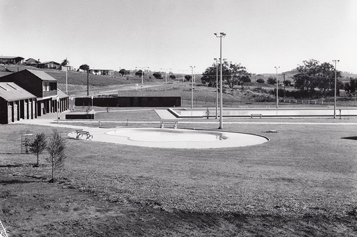
Bradbury Swimming Pool in 1970 (Now the Gordon Fetterplace Aquatic centre) Photo: Geoff Eves
Apex Park, named after the service group that had created it, was opened in June 1971. Mayor Jim Kremmer opened the Bradbury Skate Bowl on 3 June 1989.
Since the 1970's, Bradbury has greatly enhanced its image as Campbelltown's "garden suburb", popular with householders and real estate agents alike.
In 1993, the Macarthur Advertiser attempted to show the passing of the years by taking former mayor, Clive Tregear, to the site of that very first tree he planted in 1965. "Are you sure this is the right tree?" the reporter asked, peering at the canopy high above. "I don't think anyone's going to argue with me," Clive laughed in reply.