History of Gilead
The following text is from "Campbelltown's Streets and Suburbs - How and why they got their names" written by Jeff McGill, Verlie Fowler and Keith Richardson, 1995, published by Campbelltown and Airds Historical Society. Reproduced with kind permission of the authors.
Named after Israel's 'breadbasket'. Was Reuban Uther trying to enlist some sort of divine intervention for his wheat crop when he named his 400 acre (160ha) grant Gilead Farm in 1812?
After all, the Bible says Gilead was one of Israel's finest farm regions, with golden fields of wheat flourishing on the River Jordan plain. If this was Reuban's motive, it obviously worked. Because just three years later when Governor Macquarie visited the farm, he made a special note of the "promising crops" he saw.
Today, the far-flung rural area that sits between Rosemeadow and Appin is known as Gilead, in honour of the property.
Due to its sheer size, it is one of Campbelltown's largest suburbs. But not that Gilead has any great population base, being dominated by farms and bush. In fact, it only has one public thoroughfare - Appin Road. And that, of course, is named after its destination.
In 1818, Uther sold his estate to Thomas Rose. This man was pivotal in the early development of Campbelltown and is covered in more detail under the suburb "Rosemeadow". He renamed the property Mount Gilead.
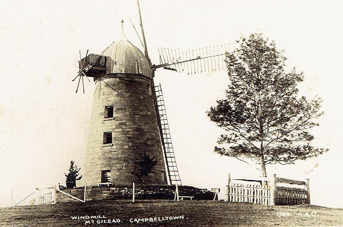
Mount Gilead Windmill originally built by Thomas Rose in 1834. M. Murgatroyd Collection
Another well-known settler in the district was Hamilton Hume, who used his farm as the starting point of his famous overland expedition to Port Phillip in 1824 with Hovell.
After Rose's death, Mt Gilead was held by several owners, including Edmund Woodhouse, who in the 1880s, turned it into one of Sydney's "social centres". In 1941, the property was sold to the Macarthur-Onslow clan, which still owns it.
December 1993 saw the release of plans to turn Gilead's green fields into an urban subdivision to house 20,000 people. But his controversial proposal has since been put "on hold" by the State Government, due to the pollution risks it would pose to the nearby Nepean River.
If suburbia does go ahead in the future, it will be physically separated from Rosemeadow by a large bushland park called Noorumba Reserve, which is Aboriginal for hunting ground. Woodhouse, Nepean and Menangle Creeks wind across the suburb and together with "Browns Bush" and "Humewood Forest" form a significant wildlife corridor which links the Georges River to the Nepean.