Ingleburn
The following text is from "Campbelltown's Streets and Suburbs - How and why they got their names" written by Jeff McGill, Verlie Fowler and Keith Richardson, 1995, published by Campbelltown and Airds Historical Society. Reproduced with kind permission of the authors.
If you claim to know the true reason why Ingleburn got its name, it's odds-on you'll get an argument in return. Because everyone seems to have a different story.
One version suggests it was named after an English farm or town by Richard Atkins, Judge-Advocate of the early colony and owner of Denham Court.
A more common tale says the "Ingleburn" title was coined by Governor Lachlan Macquarie. This comes from the fact inge means "bend" and burn means "stream" in the Gaelic tongue. Macquarie was born and bred in the Gaelic-speaking Scottish Highlands and from 1810-22 made several visits to both the Georges River and Bunbury-Curran Creek - which both flow through the area with many curves and bends.
We do know for sure that the site of Ingleburn was originally known as "Soldier Flat". This was because four old soldiers of the NSW Corps were allowed to take up farm grants there in 1809. These men were William Hall, William Neale, Joshua Alliot and Timothy Loughlin.
By 1826, Neale's 80-acre (30ha) grant was owned by an ex-convict called David Noonan who also purchased other sites, building up a farm of 193 acres (77ha) on the modern location of Ingleburn's town centre. Mary Ruse - the daughter of famous pioneer James Ruse - was Noonan's housekeeper and purchased the farm for herself in 1841.
Dr Carol Liston claims in her Campbelltown - A Bicentennial History that Mary held it until her death in 1874. "Elias P. Laycock purchased her farm in 1881 and his home was called Ingleburn House," Dr Liston wrote. So why then did the town adopt this particular name? The answer lies in the railway.
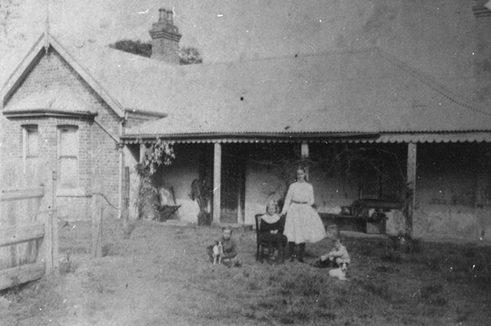
Ingleburn House, Ingleburn. Tregear collection.
As early as 1869, a rail platform had been built on the old Neale grant under the name Macquarie Fields Station. This was in tribute to the huge Macquarie Field property that lay to the north. But the year 1881 saw part of this property subdivided to become the new village of Macquarie Fields. Confusion resulted and it was decided to find another name for the platform. So in August 1883, a new name of Ingleburn Station became official, called after the nearby house. And when a village later evolved around this site, it adopted the station's name. Simple.
But this neat conclusion becomes complicated if research by the late Genevieve Tregear is taken into account. Before her death in 1995, this well-known Ingleburnian compiled a history of her home town.
Her research took her to the historical section of the NSW Railways Department, where she found evidence that a Mr Goodchap, Commissioner of the Railways in 1883, had renamed the platform Ingleburn "after an English town".
Mrs Tregear wrote to English authorities, but no trace of a town called Ingleburn could be found - not even in Kent, where Goodchap hailed from. "It's all a bit of a mystery," she concluded.
Whatever the case, the nucleus of Ingleburn township was born in 1885 when a large slice of land west of Bunbury-Curran Creek was purchased by an auctioneer and developer from Sydney call FitzStubbs, who resold in small portions. And with the residential subdivision came a host of new streets and names.
Ingleburn Road noted, of course, the old house and platform name. Most other streets honoured English localities and counties such as Chester Road, Cumberland Road, Cambridge Street, Oxford Road, Suffolk Street, Carlisle Street and Norfolk Street. Even Raglan Avenue, Belford Street, Salford Street and Phoenix Avenue were probably named under this theme as there are towns called Raglan, Belford, Salford and Phoenix Green in England.
Macquarie Road noted the early Governor of NSW, while Redfern Street recalled Dr William Redfern, the owner of Campbellfield estate, from which a part of the township was subdivided (see Minto).
Unfortunately, no records have survived to explain why many of the other early streets got their titles. The exact motive behind Nardoo Street, Flint Street, Euroka Street, Carinda Street and Drumalbyn Street can only be guessed at. Jaclyn Street no doubt honours the Jaclyn Park property of the Wells family.
The Duke of Wellington, one of England's greatest military heroes, is almost certainly the target of Wellington Avenue, while Ivanhoe Street may recall the classic novel by Sir Walter Scott. Sackville Street is another old thoroughfare, although where the name came from is uncertain. (It is interesting to note that some 1920s newspapers referred to it as "Sagville Street".)
Many of the remaining roads in the old town subdivisions appear to list Christian names - Gordon, James, Albert, Brenda, Rupert, Aubrey and Lionel. Whether they were early subdividers or family names remains to be discovered.
But the theme seems to have been a popular choice. An early rural subdivision a kilometre from the railway station called The Glen estate created Percy Street and Gertrude Road. It was described by agents as "a beautiful romantic spot suitable for country residence, fruit or vine growing, or poultry" within the "rapidly improving district of Ingleburn". Lyndia Street was later formed nearby as well.
New families began arriving and new homes to house then were built. Within only a few years a thriving village had evolved and Ingleburn Public School opened in 1887, followed by a post office in 1889. William Collins was the first postmaster and storekeeper. He and his well-known family were later honoured by the naming of Collins promenade.
Ingleburn's most impressive home was Milton Park Homestead. This was built in 1882 for hotelier David Warby. By 1909 it was owned by Thomas Hilder, manager of the silver mines at Yerranderie in the Burragorang Valley. Later this century it fell into disrepair and the owner, Campbelltown Council, demolished it in 1992 after being unable to secure a financial offer for the building.
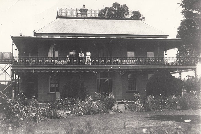
"Milton Park", Macquarie Road, Ingleburn. Campbelltown & Airds Historical Society.
A large sporting complex that now adjoins the old house site is called Milton Park. This forms part of the long band of parks that now stretch from the railway line to the Georges River. Alderman Greg Percival, who spearheaded this concept, aimed to create a "green belt" between Macquarie Fields and Ingleburn.
Street lights, parks, water and sealed roads all took their time in coming to Ingleburn. But when these things did arrive after World War I, it was "full steam ahead". From 1896 to 1948, Ingleburn had its own Council and in 1920 Mayor Arthur Harper said water connection had formally ended the town's "stagnant" period.
Kings Road, thought to have been named after King Edward VII (1901-10), led to an old rural subdivision on the river banks. The only remnants of this estate are Bensley Road, Fern Dale Street and Helder Street, presumedly named after early residents or farms.
Ingleburn Reserve, alongside the river, appears to have been dedicated as early as 1870, and was certainly a popular picnic ground for residents by the 1920s.
Development of the township increased after World War II and in the fifties, Ingleburn's population passed the 2000 mark. When an ultra-modern Hotel Ingleburn opened for business in 1955, the local press insisted the community's future was assured. "The confidence of the many builders who have erected or are erecting the many up-to-date premises now gracing the town", was held up by the newspaper as evidence.
Rivalry with Campbelltown became an important source of motivation. When that southern town got its own public high school in 1956, it was only a matter of time before the rising settlement of the north got one as well. Although lessons were held at Macquarie Fields Public School, a proper Ingleburn High School finally opened on Oxford Road in April 1960 with 156 students.
Some of the students came from burgeoning housing estates in the suburb, which had began in earnest in the early 1950s.
Matthews Square was created from the property of Harley Matthews, who had been a correspondent and poet in the Great War. Nearby Ellis Street noted a prominent local family. Robert Ellis had built a private Roman Catholic chapel in his home which he named St Angela after his late wife. Harris Street noted Ingleburn Mayor William Harris (1913-16), an early conservationist who planted many of the trees that can be found in the suburb today.
Also formed and sealed was Palmer Street, believed to honour Reverend Palmer, the Anglican minister of the 1920s who preferred to live in the township rather than at the isolated Denham Court rectory.
Images of Australiana rose to the surface in the late 1950s, when new streets like Blue Gum Avenue and Koala Avenue had a distinct "dinkum" flavour.
Green images became popular in the early sixties, resulting in Treelands Avenue, Park Street, Banksia Place and Orchard Place.
There was also expansion south of Chester Road, where open farm paddocks were slowly swallowed by new homes. As these estates were near the old Gertrude and Percy Street subdivision of the 19th Century, new streets adopted Christian names as well, to maintain a "continuity" of sorts. The result was a jumble of names including Desmond, Bradley, Myra, Roma, Edna, Ellen, Valda, Karen, Kylie, Rodney, Rebecca, Amanda, Enid, Sandra, Fiona, Kim, Clifford, Hazel, Irene and Brett. These were development throughout the 1970s and as recently as 1991 Council approved the name Michael Place for a new street. (Nearby Sackville Street Public School was opened in 1977 and named after its street address).
Ingleburn was outraged in 1973 when a Daily Mirror article described it as a "wasteland" dominated by "ugliness, lack of amenities and boredom".
The following year plans for the suburb's long-term development were finally exhibited. Parts of this "blueprint" have never been realised, such as the proposal to close Oxford Street at the town centre and turn it into a pedestrian mall. But many other ground plans have come to fruition, such as the massive new housing subdivisions.
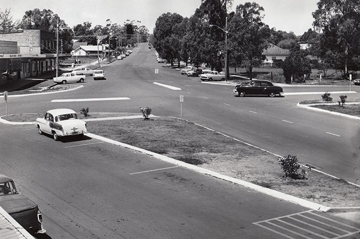
Intersection of Oxford Road and Macquarie Road, Ingleburn. circa 1969. Geoff Eves collection.
The first of these estates was developed between 1974 and 1979, north of Chester Road. But as almost 60 streets were to be created, Council searched for a theme that would provide an endless list of names. And the answer was birds.
The main thoroughfares - named after our feathered friends - became Warbler Avenue, Lorikeet Avenue, Currawong Street, Kingfisher Street, Oriole Place, Wagtail Crescent and Kookaburra Street.
A random selection of some of the surrounding street names would include the Magpie, Falcon, Lark, Ibis, Dove, Egret, Kestrel, Swift, Heron, Miner, Jacana, Honeyeater, Lyrebird, Whistler, Fantail, Swallow, Sitella, Brolga, Swan, Owl and Quail.
This estate, now considered a well-established "old" section of the suburb, surrounds both Ingleburn High School and the Holy Family Catholic Primary School, which opened in 1982.
In December 1975, the Housing Commission had announced it was preparing a new estate in "South Ingleburn". The streets created were to recall Mayors who had held office on the former Ingleburn Council.
Today, street names in this small estate near Bunbury-Curran Creek recall George Barff (who was first mayor and held the title from 1896-1901), Patrick Scanlen (1903-04), William Piggot (1904-06 and in 1907-08), Percy Lucas (1906-07 and in 1908-12), and Arthur Harper (1919-21).
When it became clear private estates would be developed nearby in the following years, Council decided in 1978 to "extend this theme".
The result recognised former Mayors George Naylor (1931-32), George Hopping (1932) and Harry Bainbridge (1939-40). Some aldermen who served on the old council are now honoured by Mahon Court, Hodkin Place, Luff Place and McInnes Place.
It seems unfair that the Percival name has never been honoured. Syd Percival was Ingleburn Mayor from 1901-03 and his grandson, Greg, was Campbelltown Mayor from 1959-61. Another to miss out was Henry Chivers, who was Mayor for a marathon term of 10 years from 1921-31.
Streets developed east of Cumberland Road paid tribute to some of the more prominent early Ingleburn landholders - Livingstone, Svensden, Cox, Keats, Thorne and Stubbs.
The completion of these new estates was supposed to herald the end of Ingleburn's growth. This was because the land between the Georges River and Collins Promenade was meant to become a entirely different suburb called "Caley".
This name aimed to recognise the early colonial botanist and explorer, George Caley (1770-1829), who made an expedition along the Georges River in 1805, mapping a section of its course nearby.
But the Caley name met stiff opposition when it was mooted in 1975. Mainly from old-time residents (such as the former Mayor Clive Tregear) who lived in the subject area and wanted to retain their Ingleburn address. In the end they won and Caley was scrapped. As a result, Ingleburn is today one of the largest suburbs in the city area.
The late 1970s saw plans drawn up to develop housing estates on this old "Caley" site. The first roads had been built and homes erected by the early 1980s, and searching for yet another street theme, Council chose "famous names associated with the automobile industry".
Main roads became Lancia Drive, Lagonda Drive, Bugatti Drive, Mercedes Road, Maserati Drive and Peugeot Drive. In all, almost 50 names were approved.
Some of these included Fiat, Ferrari, Cadillac, Ford, Alfa, Renault, Rambler, Vauxhall, Buick, Leyland, Delaunay, Daimler and Stutz. Pontiac Place, Chevrolet Place and Oldsmobile Place were formed from the old route of Kings Road, which had been blocked at Fields Road.
Taking the suburb's population into account, Ingleburn was now only outsized by Campbelltown. But this chapter has only yet looked east of the railway. It should be remembered that almost half its total area lies west of the line - Ingleburn Industrial Area and Ingleburn Army Camp.
Both are relatively modern phenomena, having engulfed dairy farms and early residential estates which were once considered an integral part of the township Stanley Street, York Street, Lancaster Street and Liverpool Street are all old tracks, and like the other side of the railway line, followed a theme of English locations or Christian names.
As early as 1919, the local newspaper noted that returned soldiers from World War I were employed in the formation and gravelling of these streets - in then called Railway Estate - "clearing off timber and scrub".
Aero Road was the main thoroughfare and stretched from the railway to Denham Court. It was named after the old Aero Estate (also known as Blomfield Estate). The Blomfields were descendants of pioneer landowner, Captain Richard Brooks (see Denham Court).
In the 1920s, much of these paddocks were sliced into a housing subdivision marketed as Aero Estate. Advertisements in April 1927 boasted it was "right at station" and buyers could chose between one, three and five acre lots from 30 pounds and acre. Within years, new homes began to surround Memorial Park, which had been established in 1924 as a tribute to the diggers of World War 1.
Additional portions of this estate continued to be developed well into the late 1950s. What was once called Denham Court Road became Memorial Avenue (as it skirted the park). The sections of Chester Road, Suffolk Street and Norfolk Street west of the railway were renamed Devon Road, Cobham Street and Norwich Road, after English localities.
New roads created in the 1950s also used a first name theme - Louise Avenue and Annette Avenue.
But the residents who settled in Aero Estate would pay dearly for being on the "wrong" side of Ingleburn's tracks. The area became a battlefield of sorts in October 1969 when Campbelltown Council announced plans to rezone the entire area for light industry.
This sparked hostile protests. "The residents of this area, consisting of retired couples who have chosen a considered peaceful area for the purpose of raising their families, now find this area to be rezoned, when there is no good reason for such a preposterous recommendation," a petition stated.
Given the public opposition, the plan was dropped, but was resurrected only a decade later when the Council overruled objections and approved light industry. In the 1990s, this area is known as the "old" section of the industrial area.
Aero Road was blocked off (becoming a minor road) and in 1987 a new road bridge over the railway connected with Williamson Road. This allowed the level crossing to be closed. Old Aero Road (winding up the hill to Denham Court) was renamed as Macdonald Road.
Both Williamson Road and Macdonald Road had been approved as names by Council in 1977, honouring some early landholders. Other local family names since honoured in the vast industrial zone include Henderson, Kerr, Stennett, Boardhurst, Inglis, Benson, Slater, Heald, Shaw and Bosci. Moorelands Road pays tribute to a nearby property that was owned by the Kerr family.
It was in 1939 that Ingleburn Army Camp was created on more than 600 acres (240ha) of the old Blomfield land, and was used throughout World War II for training military units and reinforcements.
The 1st Battalion RAR returned to Ingleburn after duties in Japan, and in March 1952 left there to go to Korea. The 1st Signal Regiment arrived in 1960 and became so involved in the town that in 1968 the Council awarded it the "Freedom of the City". The military hospital was kept busy at the time, caring for troops wounded in the Vietnam War. The camp is now home to the army's 101 Field Workshop.
Streets within the camp not only note early explorers such as Hume, Hovell, Leichhardt, Henty, Flinders, Blaxland, Lawson and Wentworth, but also recalled the "old country" with England Road and Scotland Road.
Besides old Ingleburn Reserve, Milton Park and Memorial Park (all mentioned previously in the text), there are a number of parks that pay tribute to the suburb's pioneering clans.
Westland Memorial Park was created out of the property of Mrs Westland, who lived in the historic homestead known at The Pines. Wood Park stands on old farm owned by the Wood family early this century. Symonds Reserve recalls John and Olive Symonds, while Digger Black Reserve notes a well-known footballer and bowls champ of the 1950s. The Black family were early milk vendors in the town.
Hallinan Park notes the town's first resident medico, Dr Geoff Hallinan, who ran a local practice between the 1950s and 1980s.