History of Glenfield
The following text is from "Campbelltown's Streets and Suburbs - How and why they got their names" written by Jeff McGill, Verlie Fowler and Keith Richardson, 1995, published by Campbelltown and Airds Historical Society. Reproduced with kind permission of the authors.
Glenfield gets its name from the famous property founded by early colonial surgeon, Charlies Throsby. Yet virtually none of the modern-day suburb actually stands on that old land grant!
The Glenfield property was in fact located further north, near Casula, and only ever reached as far south as The Crossroads.
So why did the settlement adopt Glenfield as its name? Well, like a lot of Australian country towns, Glenfield forged its identity through its railway station.
The first railway platform was built in 1869, but stood about a kilometre north of the present stations. This was on a site close to where the East Hills Line now veers away from the old track.
In 1869 there was no village in the surrounding area - only a few scattered farms. So in search of a name, the Railway Commissioner named the platform after Throsby's old grant.
It wasn't until 12 years later, in 1881, that the first subdivisions of the paddocks now known as the suburb of Glenfield were marketed.
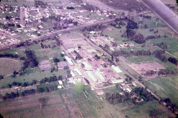
Aerial view showing Glenfield in 1959. Photo Marie Thomson
This land was originally part of the Macquarie Field property(PDF, 50KB) which had belonged to James Meehan. But because another subdivision south of Bunbury-Curran Creek had already been called Macquarie Fields, a new title had to be found.
Exactly when the "Glenfield" appellation was first used for the village is unknown. But the blocks of land sold quickly and it wasn't long before the first railway platform - sitting isolated north of the estate - closed down. It was re-opened on the present site in 1891.
But what are the origins of the name itself? The atlas shows "Glenfield" as a small village near Leicester in England - and it was here that Charles Throsby was born in 1777.
This talented surgeon came to Sydney Cove in 1802, and from 1804-09 was the commandant of penal settlement of Newcastle. Shortly afterwards, he retired to a 950 acre (380ha) grant near Liverpool. And here, Throsby built his magnificent Glenfield House in 1816.
Between that year and 1821, he became involved in exploration, making overland treks to Jervis Bay and Bathurst. He was rewarded for his discoveries with an 1000 acre (400ha) grant in the Southern Highlands - the famous Throsby Park.
A Throsby biographer, Rachel Roxburgh, has described him as a "withdrawn and thoughtful man, combining integrity with a certain lack of humour." She notes he was absorbed with a deep interest in his adopted land and its native people. "One of the first to regard the Aborigines as human beings, he lived among them and made friends with them," she wrote.
But Throsby's world came crashing down around him in the mid-1820s when a business partner fled the colony and left him heavily in debt. Worn out by ill health and the ensuing litigation and anxiety, the good doctor committed suicide at Glenfield in 1828.
Parish maps show the earliest land grantees along the fertile banks of the Georges River were William Day, William Keele and Aaron Byrne.
But by far, the bulk of the modern suburb was a patchwork of farm paddocks belonging to the Macquarie Field property. By the 1850s, all this land was owned by Martha and John Hosking (see Macquarie Fields). As explained earlier, it was in 1881 that this land was sold to developers and subdivided for residential allotments and small farms.
Glenfield's earliest streets - or dirt tracks - were now created, many possibly out of old farm laneways. Hosking Crescent recalled the subdividing family, while Harrow Road may have been named to conjure up rural images for buyers. (A harrow is a toothed agricultural implement drawn over ploughed land to level it.) But then again, Harrow was also the name of a famous English school, founded in 1571.
If Fawcett Road and Belmont Road were named by the subdividers, the reasons why appear to have died with the men involved. Maybe they noted local family or property names?
This is particularly likely for Baldwin Avenue. Members of the Baldwin family lived locally as early as 1891, and in 1948 J.E. Baldwin was elected as an alderman when Campbelltown and Ingleburn Councils amalgamated.
Canterbury Road and Newtown Road may have been named in honour of the Sydney suburbs, but some early maps list the latter as "Newton Road". Railway Parade ran parallel to the railway, north from Macquarie Fields.
A public school opened in a tent on the western side of the railway near the old platform in 1882, yet parents argued it should be moved to eastern side where the children lived. More than three decades later, in 1913, Glenfield Public School opened on its present site.
Glenfield's first church, a Presbyterian chapel, opened in 1901. The post office accepted its first mail in October 1899. By 1911, the tiny village had 170 people living in 36 homes.
The terrible state of Glenfield's roads drew some unfavourable attention in August 1929. In those days, horses and drays hauled timber along the main street, from Cleary's Mill (now Chesham Parade) to the railway station. Logs were also carried many miles to the mill, digging up the streets. On one occasion, the Liverpool doctor refused to drive his horse and buggy to Glenfield as the ruts in the roads were "literally three feet deep".
The year 1929 saw a move to build a rail spur from Glenfield Station to the river. At that time thousands of dray loads of sand were being carted from the river to Sydney by train, where they were used in the construction of Central Railway Station. But the line was heavily opposed by Glenfield Progress Association and was never built.
Well into the fifties, Glenfield remained a rural backwater. It was only in 1953 that Belmont Road and Canterbury Roads were sealed.
But Fawcett Street, which provided access to the Presbyterian Church, War Memorial Hall, Glenfield Park, three public tennis courts and the Glenfield Bakery, remained as a dirt strip. "The bakers are distraught trying to keep the germ-laden dust from the people's bread," an angry letter to editor insisted at the time.
The Campbelltown-Ingleburn News may have called Glenfield "one of the farthest outposts of the Campbelltown Empire", but in July 1957, it also noted the village was "making strides in development". It wrote: "A building block of land was sold in Glenfield recently for £500. A local estate agent said on the weekend he believes this to be a record price for land in the village. With such prices being realised for land in the town it is not surprising to see many new buildings in the course of erection."
A major landmark was the Frank Whiddon Masonic Homes which was opened in 1953. It was named after the Masonic Grand Master of the 1940s who had sponsored the project.
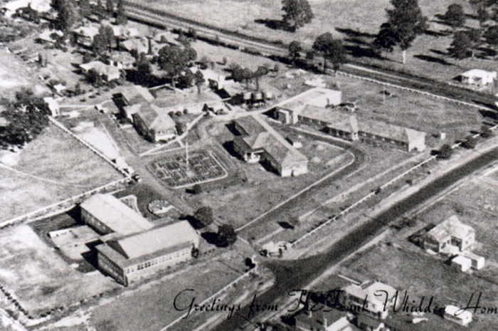
Aerial view of the Frank Whiddon Masonic Homes, corner Belmont Road & Canterbury Road, Glenfield in 1959. John Blain Collection.
Charles Symonds had left the land to the Masonic Lodge on his death. The property itself was known as Easton Park, after his wife, Ethel Easton Sydmonds.
The 1950s and 1960s saw new roads created as modern subdivisions were opened on the outskirts of the tiny village. An old thoroughfare which had been known to local folk as "Railway Avenue" was renamed by developers as Trafalgar Street. This was most likely in honour of the legendary sea battle of the Napoleonic Wars which made a hero of Lord Horatio Nelson. Another farmed clash of arms in that was against France was the Battle of Waterloo in 1815 - hence Waterloo Place.
English Street possibly emphasises the subject bias of the developers. Other names from English history books can be found on street signs such as Stirling, Blenheim, Tudor and Salisbury.
Hurlstone Avenue is a tribute to the famous school, located west of the railway.
Hurlstone Agricultural High School was established in 1906 near Sydney - the suburb of Hurlstone Park gets its name from the school. To escape the urban sprawl, Hurlstone was relocated to Glenfield in 1926, but retained its old name. The school was designed to prepare students for farm work, and for most of its life was a bastion of male learning. It wasn't until 1979 that the high school's first female students were admitted.
Roy Watts Road gets its name from a "distinguished old boy" of Hurlstone who began his studies there in 1929. He achieved an outstanding record in academic and sport, and went on to Sydney University. By the late 1930s he was an officer with the Department of Agriculture, and from 1965-80 was NSW Director of Agriculture. As a mark of respect, the road running past the school was named after him.
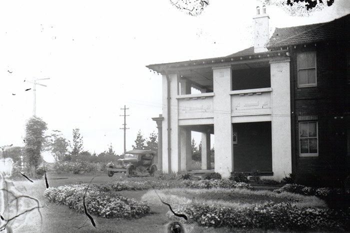
Principal's residence at Hurlstone Agricultural High School
Quarter Sessions Road may get its title from the fact that it leads to historic Macquarie Field House. Thomas Reddall lived at this house in the 1820s and the road name is known to be very old. "Reddall was a magistrate and justice of the peace and may have conducted related duties there," suggests the president of Campbelltown and Airds Historical Society, Alex Goodsell. At the time, a criminal court held four times a year by rural justices of the peace were known as Quarter Sessions. "The period certainly predates the opening of the first court house at Hammonds Inn in 1826," Mr Goodsell said.
The exact origin of Wentworth Avenue, Chelsea Place, Grahame Street, Lalor Street and Foreman Street are not certain, as they were chosen by estate developers.
Kennett Place recalls one of the suburbs oldest families. It was in 1902 that the clan first settled on a farm by the river. Glenfield Progress Hall was constructed in 1925 with money loaned by C.C. Kennett.
Magee Lane is a memorial to Isabella Magee, who ran the Glenfield Post Office from 1901 to 1954. In that year, the job was taken up by her daughter, Isobell, who retired in 1962.
Further toward the river, Georges Road, which began its life as "St Georges Parade", was declared a public road in 1958. It was heavily used as an access road by sand miners.
Cambridge Avenue was built in the early 1980's to replace the old Cambridge Avenue - remains of which can still be seen behind Fergusson and Goodenough Streets.
In 1926, the local newspapers referred to it as an "unnamed road leading from Canterbury road to the Georges River" through the middle of farmland owned by the Kennett family. "The road is very pretty...but there is not a track right or left to the water when you get there," it was reported.
When the army built a low level bridge over the river, connecting Glenfield to Holsworthy Army Camp, it became known as "Military Road". In 1948 the army agreed to allow the public to drive across the bridge as a short cut to Sydney. Local motorists quickly took this for granted and when the army suddenly closed the road again in late 1957, there was outrage. Vocal protests by Campbelltown Council led to the road being re-opened in less than a month.
But the tenuous existence of road link was now obvious. Not only did the army own the bridge, but the Kennett family owned the road, which had never been dedicated as a public thoroughfare.
The situation reach its climax in 1978 when J.C. Kennett announced he was going to close the road because he had become "increasingly irritated" at speeding vehicles knocking down his fences, allowing his stock to stray.
His decision effectively blocked 11,000 daily commuters from using the short cut across the military land. An alarmed Council convinced Mr Kennett to delay his action. In the end, a strip of land next to an electricity easement was resumed, 200 metres north of the old road, to build a new thoroughfare. And despite a string of promises by both major political parties, successive State Governments have refused to build a high-level bridge over the river.
By 1971 the estimated population of Glenfield was only 1500. Even as late as 1974, the local press featured stories on the poultry and pig farms at the back of the village.
But development was coming. The early 1970's saw a host of new estates spring up in the east, creating almost 60 street. A town planner involved in the development had earlier been a patrol officer in Papua New Guinea, so the Council - which had been in search of a theme - decided to name the new roads and street after locations that can be found within the island nation to our north.
The main thoroughfare were therefore called Owen Stanley Road, Popondetta Place, Bougainville Road, and Trobriand Crescent. These noted the Owen Stanley mountain range, the town of Popondetta, Bougainville Island and the Trobriand Islands.
Some other names that can be found include Goodenough Bay, Mount Hagan, Manus Island, Woodlark Island, Cape Gazelle, Bensbach River, the Calvados chain of Isles and Fergusson Island. Also noted is the Kokoda Trail where Australian soldiers halted the Japanese advance in 1942.
The settlements of Kerema, Lae, Gona, Goroka, Kikori, Epo and Buna are included in the street names, as is the capital city Port Moresby.
In March 1975, work started on a bridge over Bunbury-Curran Creek, linking Canterbury Road to Harold Street in Macquarie Fields.
Glenwood Public School, (named after a subdivision from the 1880's) opened in 1986.
And after 30 years of promises the East Hills to Glenfield rail link was opened in December 1987, cutting 20 minutes off the trip to Sydney.
Blinman Park is named after a prominent Glenfield family as is Childs Reserve and Kennett Park.
Seddon Park honours Dr Herbert Seddon, a veterinary surgeon who was the first director of Glenfield Research Station from 1923-36. His 1964 obituary in the local press said: "At Glenfield he did much to advance conditions for the community and was mainly responsible for obtaining the park at Glenfield which has been named "Seddon Park" in recognition of his work in the area."