Macquarie Fields
The following text is from "Campbelltown's Streets and Suburbs - How and why they got their names" written by Jeff McGill, Verlie Fowler and Keith Richardson, 1995, published by Campbelltown and Airds Historical Society. Reproduced with kind permission of the authors.
James Meehan (1744-1826) was instrumental in founding the suburb of Macquarie Fields. Having been granted 2020 acres by Governor Macquarie for surveying the land around Liverpool, he names his home 'Macquarie Field' in appreciation.
In 1810 the Surveyor General James Meehan had 10 acres of his land grant at Macquarie Fields in cultivation, 40 acres cleared and a house with 4 men employed. A huge farm, it covered much of modern Macquarie Fields and Glenfield, and as far west as Denham Court. The early brick home was soon nicknamed 'Meehan's Castle' by local farmers.
Yet, the busy surveyor rarely had time to enjoy his home and spent more time sleeping under the stars then in his own bed. The Reverend Thomas Reddall actually ran a boarding school for young upper-class boys from the house for many years.
It wasn't until his retirement in 1822, that Meehan was able to dedicate himself to his farm. He grew wheat, barley, maize and vegetables, planted a huge orchard, and raised live-stock. On his death in 1826, the whole estate was inherited by his only surviving child, 18 year old Thomas Meehan.
Thomas married an Appin lass, Mary Ann Tress, but was too young and inexperienced to handle the management of the Macquarie Field - or the debts left by his father. By Thomas Meehan's 21st birthday in 1829, the creditors were hammering at his door and between 1829 and 1835 he managed to lose all the family properties, including the Macquarie Field, which he sold to Samuel Terry.
Samuel Terry died in 1838, leaving the old Meehan grant to his daughter, Martha, for who it's believed Macquarie Field House(PDF, 50KB) was built. Much of the estate was divided into small farms, while Martha made her home in the hilltop mansion with husband, John Hosking (the first mayor of Sydney), and their children.
For much of the 1860s, the house was used as a private school by Reverent George Fairfowl Macarthur. It was at Macquarie Field House that the first school cadet corps was founded and the cadet uniform was worn by the boys as a general school uniform. Although it remained in Martha's ownership until her death in 1877. The house and western part of the estate were sold to the Ashcroft family, but land east of the railway was put up for sale in 1881.
A tobacconist-turned-developer, Thomas Saywell, bought 1558 acres (623ha) hoping to reap profits from subdivision. But the scheme was hardly a raging success and little now remains of the venture except for Saywell Road. Pritchard Road recalls another early speculator, William Pritchard, who is also remembered by Liverpool's Mount Pritchard.
In 1883 William E.H. Phillips purchased a large part of Saywell's land and drew up elaborate plans to convert the bushland into a new mini-city. Called Glenwood Estate, the elegant location was to feature grand boulevards and plush avenues, as a perfect country address for the well-to-do city gent. The opening of Macquarie Fields Station in 1888 only boosted his sales.
But the real estate market collapsed during the 1890s depression and Glenwood never grew to anything more than a few scattered homes amid the bush. By 1892, Phillips was bankrupt and thrown into prison for fraud and it wasn't until early this century that a proper village began to take shape.
The oldest roadways - most being legacies of the Glenwood Estate - were Victoria Road (named after Queen Victoria), Parliament Road and Cadogan Avenue.
Imaginatively titled First Avenue was followed by Second, Third, Fourth, Fifth and Sixth Avenue, stretched all the way to the riverbank.
Brooks Street may have recalled the owners of the Denham Court estate, while Atchison Road was probably named after an early landholder/developer. Others were given Christian names such as Harold Street, Evelyn Street, Alice Street, Edgar Street and Elizabeth Street.
Water and electricity were connected in 1936, but much of the village was small farms and vacant land. For this reason it became a popular refuge for the homeless who built makeshift huts in the bush during the Great Depression.
A map held in Campbelltown Library, shows the streets that were already created by the early 1950s. These included Myee Road (origin unknown) and Waratah Crescent, named after the floral emblem of NSW.
Bunbury Road was named after nearby Bunbury-Curran Creek, and a 1954 newspaper article notes the tough task of "clearing and forming" of the roadway. The old library map shows Bunbury Road had once been joined by "New Road". A former mayor and long-time resident, Keith Fraser, recalls this name as later changed to Church Street, honouring the nearby Baptist Church.
Meanwhile, after being held by several private owners, Macquarie Field House had been acquired in 1944 by the NSW Department of Agriculture for animal research. The house fell into disrepair and in 1958 was planned to be demolished. But the National Trust intervened and negotiated a lease for a "public-spirited citizen", David Jamieson, who went on to fully restore the house.
In June 1958, the local press praised the rapid pace of the village's progress. "The number of new homes now being built is not the only sign of progress in Macquarie Fields," it was reported. "A few short weeks will see the completion of three modern shops in the shopping centre and the progressiveness of the builder of one block is clearly shown by the fact a doctor's consulting rooms are included in his buildings." A modern chemist was also built.
After two decades of public agitation, a Macquarie Fields Public School had been opened in March 1958. Nearby Macquarie Fields High School wasn't built until 1981, originally as a temporary facility. Permanent buildings were completed in 1987.
The coming of the 1960s saw a host of new housing estates.
George Hudson Ready Cut Homes built over 60 homes in Wattle Avenue - named for the tree species, as was nearby Cyprus Street. Burns Avenue was named in honour of an early subdivider.
The creation of Alexander Crescent (possibly named after the developer) near the railway station caused much controversy as the new houses approved by Council in 1960-63 were often flooded. Bingara Road (Aboriginal for spring) was also formed, as was Curran Avenue. Like Bunbury Road, it was named after the creek.
One subdivision to the north drew a "royal" inspiration from Victoria Road, with its streets noting the Dukes of Windsor, Gloucester, Clarence and Argyle.
And as many of the suburb's earlier roads had been given Christian names, some of the new estates followed suite with Noeline, Edith, Maxwell, John, Adam, Cedric, Wilfred, Nigel, Kenneth, Harvey and Adrian all getting a mention.
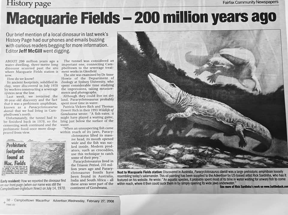
In July 1970, the streets of Campbelltown, particularly Macquarie Fields, was abuzz with talk of a pre-historic discovery. Animal footprints solidified in clay were discovered during the construction of a sewage tunnel near the railway line at Macquarie Fields Railway Station. Dr Anne Howie from the Department of Zoology at Sydney University identified the animal as a Labyrinthodont, known as Paracyctosaurus Davidi. It measured 3 metres in length and was similar to a crocodile with wide opening jaws which contained very small teeth. Its ancient footprints had been preserved for 200 million years! Unfortunately the tunnel had to be cemented and once again the footprints disappeared from sight, but not before the university team made recordings for official records.
(Article by Jeff McGill 2008, sourced from the Campbelltown and Airds Historical Society)
By 1971, the population was 3700. But as far as sudden growth goes, Macquarie Fields hadn't seen anything yet.
It was in 1969 that Campbelltown Council had sold a large slice of land it owned, east of Harold Street, to the Housing Commission. And by 1971 the plans for the site were tabled in the local press.
"The Housing Commission … will carry out a comprehensively planned development involving preservation of the best features of the existing landscape and the closure of all existing roads within an area of about 300 acres (121ha) of land." it was reported.
Built at the breakneck speed of 25 dwellings per week, the estate was ready for its first residents by September 1973.
New streets were named after trees and shrubs, hence Rosewood Drive, Melaleuca Drive and Eucalyptus Drive. Some others noted including Maple, Mulga, Grevillea, Ironbark, Blackwood, Hickory, Cooba, Teatree, Cottonwood, Olive, Bunya, Hakea, Peppermint, Mahogany and Celtis.
Flinders Field and Bass Reserve note early explorers George Bass and Matthew Flinders, while Caley Park recalls botanist George Caley, who explored and mapped the area in the early 1800s.
James Meehan High School, named in honour of the early surveyor, was opened in 1975. Nearby James Meehan Park also honours the local pioneer.
Guise Public School recalls Richard Guise, the first settler to be given a land grant in the riverside area. But this choice was a last minute one, as the school was originally supposed to be called "Bunbury PS". This was to note nearby Bunbury-Curran Creek. Curran Public School retained its name, and both schools opened in 1975. Jack Curran was Meehan's axeman and camp assistant, while Major General H.E. Bunbury was a British official who often corresponded with Governor Macquarie.
Glenquarie Shopping Centre was opened by NSW Premier, Tom Lewis, in September 1975.
By this time, Macquarie Fields was a huge suburb, and in 1975 Council proposed splitting it into two separate pieces. The old village section would retain the original name, while the area between Harold Street and the Georges River was to become the new suburb of "Glenwood". This recalled the William Phillips' subdivision of the 1880s.
But the Housing Commission vigorously opposed the plan. This was because it was keen to integrate its development with the surrounding community. And detaching it from the rest of Macquarie Fields would only create divisions, the Commission argued. After much debate, "Glenwood" was dropped.
In 1975, work began on a new road bridge over the Bunbury-Curran Creek, linking Harold Street with Canterbury Road in Glenfield. "This will be the first stage of the major north-south road proposed to link the northern villages to Campbelltown," the press reported.
The final link in this chain was joined in the early 1990s when old Fields Road (named after its destination) was closed as the major thoroughfare. In its place, Harold Street was extended south to meet up Collins Promenade.
The late 1970s and early 1980s saw private housing estates spring up south of the Housing Commission estate, once again reshaping the map.
These streets were named after flowering plants, some of the new roads being Lantana Street, Geranium Avenue and Hyacinth Avenue. Other names include Amaranthus, Ficus, Casurina, Buttercup, Cherry, Petunia, Cyclamen, Cranberry, Clover, Gentian, Correa and Helica.
What was once the eastern extreme of Saywell Road is now Astelia Street, Groundsel Avenue and Knotwood Avenue. Some of the more recent streets, still being developed in the mid-1990s, include Azalea Place and Magnolia Place.
In May 1986 the first stage of Simmos Beach Recreation Area was officially opened. It is named after Bob Simmonds, a past resident and "likable villain" who illegally mined sand from the river banks in the 1950s.
Hazlett Park pays tribute to a poultry-farming family that once lived on the site. Thomas Atkins Walk recalls the name of an original land grantee.
Even as late as 1995, Macquarie Fields still faced sizable development. At time of publication, Monarch Homes was yet to embark on its much publicised residential estate (which will encompass a golf course) on the hillside between Macquarie Field House and the railway station.
This will be called Macquarie Link Estate and Monarch is hopeful of naming the yet-to-be-built streets after elements from the life and times of Governor Macquarie. If this new estate becomes a separate entity, the most likely option for a new suburb name would be "Meehan."
More information about the history of Macquarie Fields can be found in the following works available at Campbelltown City Library.
Campbelltown - The bicentennial history by Carol Liston 1988 pub. Allen and Unwin Australia.
Macquarie Fields Pamphlet file: small collection of source material (please ask library staff to access)