Flood and Storms

In NSW storms and floods cause more damage than any other event. In preparing for either event there are some simple precautions that people should take in order to minimise the potential impact.

Floods

Flooding results in relatively high water levels which flow over natural or artificial banks in any part of a stream, river, estuary, lake or dam or any local drainage system before it enters a watercourse.

Elevated sea levels, large waves or tsunamis can also cause coastal flooding.

Flooding can be a positive occurrence by providing water to wetland ecosystems, replenishing soil moisture and nutrients and providing habitat and food for wetland wildlife.

Flooding can also cause substantial damage to homes and businesses, critical infrastructure, and farming. However, the negative effects of floods can be reduced with good planning and the right actions.

Flash flooding is the most likely kind of flood to affect residents of Campbelltown City.

Storms

Storms can happen anywhere at anytime of the year and are the most frequent emergency affecting people in NSW.

Storms can be accompanied by torrential rain, strong winds, large hailstones and lightening.

Storms may result in flash flooding, un-roofed buildings, damaged trees and power lines and can pose a significant safety risk to people, animals, households and businesses.

Severe Storms

To minimise damages and injuries during a severe storm, here are some points you can use as a guide:

Before the storm

  • Clear all loose materials (metals, tools, furniture, large bits of wood) from around your house and garden.
  • Trim large branches, especially those hanging over the house and around powerlines, but if you feel that a specific area needs attention, contact Council. Never attempt to do it yourself.
  • Have a battery operated radio with fresh batteries.
  • Have masking tape - in case you need to tape the windows in the threat of very high winds.
  • Check your home emergency kit is up to date.

During the storm

  • Listen to your local radio for important information, updates and/or instructions.
  • Secure all pets and shelter all vehicles and protect them with tarpaulins or blankets
  • In the instances that there are intensive and strong winds, tape your windows in the 'x' and then the '+' fashion (so it creates a star '*' pattern).
  • Remain inside in a strong safe place of the house.
  • Locate and check your home emergency kit is stocked with essentials
  • Keep clear of windows, glass pipes and anything metal
  • If outdoors, shelter in a car and never under a tree.
  • If there is no vehicle available, crouch - do not lie down - in a hollow.

After the storm

  • Listen to your local radio for official information and guidance.
  • Check your house for damage - if you find it is unstable and unsafe then find a strong part of your house to shelter in.
  • Contact the emergency services if you require urgent assistance and seek help from neighbours and family.
  • Do not go investigating the damages in your neighbourhood, stay and help others.
  • Be aware: there could be fallen powerlines, unstable buildings and loose branches and trees.

Drain and canal safety

Drain and Canal Safety

Campbelltown has an extensive system of open canals and stormwater drains as part of the flood protection of the city. You should be aware that entering these canals and stormwater drains is dangerous.

Why are drains and canals dangerous?

Drains and canals carry rainwater from our streets to our rivers and creeks. They are dark, wet and slippery making it easy to slip and fall. It is also difficult for others to hear your call for help if injured.

Entering a drain or canal could cost you your life and place others at risk rescuing you.

Anyone entering a drain faces the threat of:

  • Rising water levels, even in sunny dry conditions
  • Rainwater falling many kilometres flowing downstream, arriving suddenly and unexpectedly
  • Slow moving flows that can quickly become raging torrents
  • Poisonous gases and lack of oxygen that may present in drains at any time
  • Contaminated or unsanitary water conditions
  • Flash Floods

Flood Detention Basins

As well as drains and canals, Campbelltown has flood detention basins across the city. They assist in temporarily holding flood water when extreme floods occur, such as a 1-in-100 year event.

Many of these detention basins are sporting fields or parks. It is important to remember that these areas can also be very dangerous when extreme flooding occurs in the city.

Flash floods

Flash Floods

Flash floods happen when a large amount of rain falls in a localised area over a very short period of time.

These localised storms are generally beyond the capacity of the underground drainage system.

Excess water runs along the low points of the area which can include roads, gardens, train lines and streets, and sometimes through homes and businesses.

How often do flash floods occur?

These storms are fairly rare, occurring on average every five to ten years. Larger storms that can cause property damage generally occur on average once every 20 to 50 years.

Climate change projections suggest we can expect more extreme weather events including heavy storms that deliver a large amount of rain in a short period (2-24 hours). This is despite the fact that annual rainfall volumes are expected to decrease.

How can I stay safe in a flash flood?

The State Emergency Service has produced a Community FloodSafe Guide to help you prepare and protect your household from floods.

See further information about our Flood Action Plan.

Flood action plan

Flood Action Plan

If flooding is likely a Flash Flood or Flood Watch is issued by the Bureau of Meteorology and you should be prepared to act should this flooding occur.

Residents

  • Listen to your local radio station for information, updates and advice
  • Locate and check your Home Emergency Kit is ready
  • Check on your neighbours and make sure they are aware of the Flood Watch
  • Move pets, including agisted animals, to high ground

Business Owners and Managers

  • Locate and activate your Business Flood Safe Plan (developed by working through the Business Flood Safe Toolkit)
  • Check neighbouring businesses are aware of the Flood Watch
  • Where possible, back up records and store off-site
  • Make preparations to raise or relocate stock, records and equipment
  • Find out about evacuation routes for your business and make sure your employees know when they are likely to close. This will ensure they can leave safely when a Flood Watch is issued

Rural Property Owners

  • Relocate livestock and farm equipment, including pumps, to high ground
  • Check sheds and outbuildings. Equipment, feed and chemicals should be raised or moved to high ground

All Properties

If isolation is likely, have sufficient non-perishable food, essential medications, fuel and other necessities to last at least a week. Remember to include pet food and fresh water. This is apart of your Home Emergency Kit.

What do I do during a flood?

  • Never drive, ride or walk through floodwater - this is the main cause of death during floods. Floodwater may be deeper and faster flowing than you think and may contain hidden snags and debris. This includes causeways and low-lying roads
  • Stack possessions, records, stock or equipment on benches and tables, placing electrical items on top
  • Secure objects that are likely to float and cause damage
  • Relocate waste containers, chemicals and poisons well above floor level
  • Keep listening to your local radio station for further information, updates and advice
  • Keep in contact with your neighbours
  • Be prepared to evacuate if advised
  • Act early, as roads may become congested or close

How do I evacuate?

During a flood the SES and other emergency services may ask you to prepare for evacuation.

The SES aims to keep people safe and minimise the risks to life and property when floods occur. It is important that you follow any advice given to you in an evacuation situation.

Being prepared early will allow you to respond quickly should you need to evacuate.

  • Be sure to have your Home Emergency Kit ready to go and add important papers, valuables and mementos
  • Don't forget to take your Home Emergency Kit with you
  • Turn off the electricity and gas at the mains before you leave and turn off and secure any gas bottles
  • Prepare to take your pets with you.

Recovering from a severe flood

A local recovery centre may be established by Department of Family and Community Services. This centre will be staffed by representatives from a range of government departments and community agencies to help you return to normal living. At the centre you will be able to get advice on everything from insurance to counselling.

In the event of a flood, information will be available from the Department of Family and Community Services State Disaster Recovery Centre on 1800 018 444.

For further information of flood preparation contact the State Emergency Service (SES) on 132 500 or see their website.

Floodplain management

Floodplain Management

What is a flood?

A flood occurs when there is water where it shouldn't be.

Flooding occurs in two ways. The first is when rain falls and the water runs downhill, eventually reaching a drainage pit, creek or river. This is known as overland flow.

The second is when a river or creek has more water running through it than normal and begins to increase in depth, covering land that it didn't before. This is known as mainstream flooding.

Flooding in Campbelltown Local Government Area

Compared to areas you may have seen on the news in recent years, flooding in Campbelltown is not very severe and stormwater drainage systems have been well planned, built and maintained.

Flooding which does occur is generally of very short duration, but also with short warning times. Most of the Campbelltown Local Government Area (LGA), if flooding does occur, will experience overland flooding. Very few properties on both the George's and Nepean Rivers experience mainstream flooding.

Managing flooding in Campbelltown

To manage flooding, it is important to first understand how flooding occurs, what areas are most at risk and then ways to manage the flooding can be developed. The NSW Government Floodplain Development Manual outlines the following method for achieving this. By following this process, Council can also apply for financial assistance from the State Government in the development of flood studies, floodplain risk management studies and plans and construction of flood mitigation works.
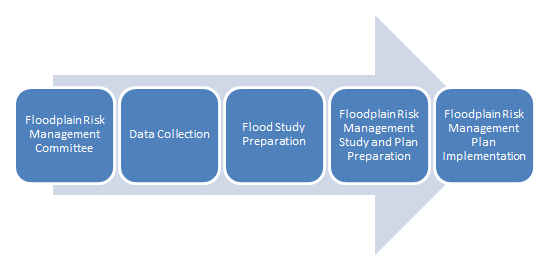
Floodplain Study plan

Flood studies and Floodplain Risk Management Studies and Plans

A Flood Study takes all the relevant information in the area to model how a flood will occur. This information includes topography, stormwater drainage infrastructure locations of buildings and anything else which may impact how water moves through a catchment. A different range of flood events are then modelled and maps showing the depth of the flooding, how fast the flood waters move and the flood hazard are produced.

The information from the Flood Study is then used to complete the Floodplain Risk Management Study and Plan. The Floodplain Risk Management Study uses this information to identify areas which will be impacted by flooding and looks at ways to minimise these impacts. Generally, the Study will identify areas where there may be flood waters moving through a house or which will be dangerous for the community.

Campbelltown Flood Studies and Floodplain Risk Management Studies and Plans

Council has completed a flood study for the Bow Bowing Bunbury Curran Creek Catchment and has finalised the Bow Bowing Bunbury Curran Creek Catchment Strategic Floodplain Risk Management Study and Plan.

Volume 1 - Bow Bowing Bunbury Curran Creek Strategic Floodplain Risk Management Study and Plan(PDF, 114MB)

Volume 2 - Bow Bowing Bunbury Curran Creek Strategic Floodplain Risk Management Study and Plan(PDF, 55MB)

Work is currently underway for the preparation of a flood study for a number of catchments to the south of the LGA (mainly around the suburbs of Airds, St Helens Park and Rosemeadow). This is expected to be completed towards the end of 2022.

Floodplain Risk Management Committee

The Bow Bowing Bunbury Curran Floodplain Risk Management Committee meets as necessary to discuss and review Flood Studies, Floodplain Risk Management Plans and other flooding issues.

Property flood levels and extents Information

If you need information on flooding for a specific property, please complete the online Stormwater Advice Request Form.

The form also has the option for a contour plan and stormwater network details to be provided.Payment is required before processing the application. Please allow approximately 10 working days before the information is sent to you by e-mail.

Council may not have flood information for every property, as some locations within the Campbelltown CBD may be outside the flood study extents.  

Flood information resources

Please see the Campbelltown Flood Study Areas which defines the boundary extends of the flood study information available in the Campbelltown City area.

Additional flood maps and documents for the Campbelltown CBD are available on Council’s Public Exhibition page. Flood information is also available on the SES NSW Flood Data Portal

For additional information regarding property flood levels, please contact Council on 02 4645 4000 or by email at floodstudy@campbelltown.nsw.gov.au